✓ Source: REIN MLS #10660491 · record updated Nov 15, 2026 · synced every 2 min · your inquiry is never resold
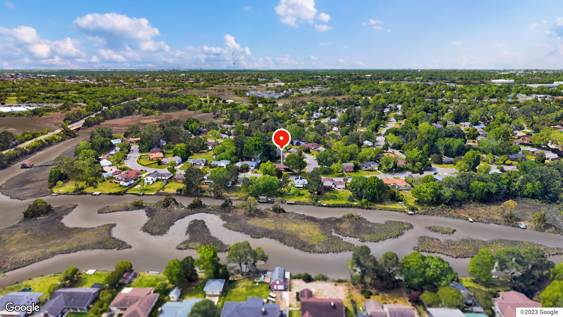
Exterior · 1 / 50
4beds
3baths
2,141sqft
$191per sqft
8days on market

19 Wheatland Dr, Hampton, VA 23666

Under ContractResidential · built 1959 · 0.29 acres · RIVERDALE · MLS #10660491

OverviewAbout this home

Welcome to Riverdale! This BRICK HOME offers 4 BEDROOMS, 3 FULL BATHS & 2,160sf on a CORNER LOT! The OPEN FLOOR PLAN connects the kitchen and living room, with a LARGE ISLAND offering seating for several. Living room sliding doors with built-in blinds open to the sunroom. TWO PRIMARY SUITES on opposite sides of the home provide flexibility and privacy. One features a BRICK FIREPLACE framed by BUILT-IN SHELVING and access to the 241 SF SUNROOM and side yard; it could also serve as a family room! On the opposite side, you'll find the second primary suite with a full bath w/ WALK-IN SHOWER, plus two additional bedrooms. Enjoy a LARGE DECK overlooking the spacious L-SHAPED YARD with PRIVACY FENCE, double gate, wooden playground and PICNIC AREA and room for games, firepit and gatherings! A detached 188sf WORKSHOP with an INVITING COVERED PORCH adds space for projects and relaxation. Convenient to LANGLEY AFB, PENINSULA TOWN CENTER shopping and dining, and entertainment at HAMPTON COLISEUM!

Listing courtesy of Deborah Warren · Liz Moore & Associates LLC · REIN MLS #10660491

Facts & features

TypeResidential
Year built1959
Price / sqft$191
HOANone
Taxes$4,188/yr
CountyHampton VA
MLS #10660491

Interior

Bedrooms
4
Full baths
3
Approx. sqft
2,141
Stories
1
Flooring
Carpet, Concrete, Laminate/LVP
Ensuite bedrooms
2
First-floor bed & full bath
Yes
Total rooms
8
Other rooms
1st Floor BR, 1st Floor Primary BR, Attic, Foyer, PBR with Bath, Sun Room, Utility Closet, Workshop
Appliances
Dishwasher, Disposal, Dryer, Dryer Hookup, Microwave, Elec Range, Refrigerator, Washer, Washer Hookup
Equipment
Ceiling Fan, Security Sys

Construction & exterior

Style
Ranch
Subtype
Detached
Foundation
Crawl
Roof
Asphalt Shingle
Exterior
Brick
Pool
No Pool
Fencing
Privacy,Wood Fence

Utilities & systems

Heating
Forced Hot Air, Nat Gas
Cooling
Central Air, Window/Wall
Water heater
Gas
Water
City/County
Sewer
City/County

Lot, parking & ownership

Lot size
0.2900
Subdivision
RIVERDALE
Zoning
R13
Ownership
Fee Simple
Garage
No
Parking
2 Space, Off Street, Driveway Spc
Possession
CLOSING
Disclosures
Disclosure Statement

Sources: REIN MLS record

Tom & Dariya's overview

Our read on this home

by Tom & Dariya Milan, REALTORS® · Brokered by LPT Realty

At a glance

19 Wheatland Drive sits in Hampton, Virginia, just five minutes from Joint Base Langley-Eustis. This 1959 ranch-style home offers four bedrooms, three baths, and 2,141 square feet on a quiet residential street. Air Power Park is half a mile away. It is a solid, well-located address in the heart of 23666.

Read the full overview ↓

Why this home stands out

What sets 19 Wheatland Drive apart is the combination of size and proximity you rarely find together. Four bedrooms and three full baths in a 1959 home means generous room counts by the era's standards. The lot sits close to daily errands, green space, and two military installations. Hampton homes for sale at this square footage and this close to Langley AFB are worth a close look. The bones are mid-century; the location is hard to beat.

RIVERDALE and the Hampton real estate market

The streets around Wheatland Drive carry the quiet, established feel of a neighborhood that has been here a long time. Mature trees line the roads. Homes from the late 1950s and early 1960s sit on generous lots with real setbacks from the street. It is the kind of block that anchors homes for sale in 23666 year after year. Hampton itself is one of the oldest English-speaking settlements in the country. The city wraps around the water on three sides, giving it a distinct coastal character. Downtown Hampton has a working waterfront, an arts scene, and a convention center. Getting around is straightforward. Interstate 64 is close, and the Hampton Roads Bridge-Tunnel connects you to Norfolk and Virginia Beach in under thirty minutes. Daily life here moves at an easy pace without feeling remote.

What's nearby

Groceries are covered in every direction. A BP station is a half mile out, Walmart Supercenter and Kroger Bakery are both within a mile. For a quick meal, Krispy Krunchy Chicken is just 0.5 miles away, IHOP is 0.6 miles, and Bojangles is 0.7 miles. Coffee is easy too — Starbucks Coffee Company and a 7-Eleven are both under a mile. Planet Fitness is 0.9 miles for a workout. Air Power Park, with its outdoor aircraft displays, is right at 0.5 miles. Waterwalk at Central Park is 0.6 miles, and Parklawn Memorial Park rounds out the green space options at under a mile.

For different buyers

Base commute and VA loan notes

Joint Base Langley-Eustis is about five minutes by car — one of the shortest base commutes you will find in Hampton. NSA Hampton Roads is roughly 14 minutes out. VA loan financing is common at this address, and the four-bedroom count lines up well with E-6 and above BAH tiers. The 1959 construction means the home has had decades to settle, and the layout is straightforward.

For first-time buyers

A 1959 home with four bedrooms and three full baths gives you more space than most first purchases. The neighborhood is calm and well-established. Errands, parks, and dining are all within a mile, so you are not dependent on a long commute for daily needs. Anyone comparing homes for sale zoned for Hampton High School and homes for sale zoned for Paul Burbank Elementary School will find this address falls within both attendance zones.

More buyer questions

How far is 19 Wheatland Drive from Joint Base Langley-Eustis?

The drive is about five minutes under normal traffic conditions. It is one of the closest residential streets to the main gate in Hampton.

What year was 19 Wheatland Drive built?

The home was built in 1959. It is a mid-century residential property typical of the established neighborhoods in this part of Hampton.

Is 19 Wheatland Drive in a flood zone?

Flood zone information for this address is covered in the FloodRisk tile on this page. Check that section for the current FEMA designation.

How many bedrooms and bathrooms does 19 Wheatland Drive have?

The home has four bedrooms and three full bathrooms across 2,141 square feet.

Where is the nearest grocery store to 19 Wheatland Drive?

A BP is just 0.5 miles away. Walmart Supercenter and Kroger Bakery are both within 0.8 miles.

Want to see 19 Wheatland Drive in person? Tom and Dariya Milan can walk you through every room and answer your questions about the neighborhood. Reach out to set up a visit.

Summary generated by AI from public records and publicly available information.

Schools · VaHome School ScoreAssigned schools

Our own 1–10 rating, scored from Virginia Department of Education data.

HighHampton High School
5.7/10
Down 0.4 from 2024–25
MiddleC. Alton Lindsay Middle School
6.4/10
Up 2.2 from 2024–25
ElementaryPaul Burbank Elementary School
4/10
Down 0.8 from 2024–25

VaHome School Score — calculated by VaHome.com from Virginia Department of Education assessment, progress, and attendance data. Attendance zones come from the MLS listing record; confirm the current zone with the school division before making an offer.

How Far Is?

Driving distance by road and typical drive time via Google Maps, to the nearest location of each.

Also nearby

Distances are straight-line (as the crow flies) from this property, not driving miles. Places within ~1 mile, nearest first. Powered by Google Places.

Homes like this one sell fast — see the next one first

Hampton$345K – $475K4+ beds

By subscribing you agree to receive listing emails from Tom & Dariya Milan, Realtors, at most one a day. Unsubscribe anytime · Privacy PolicyBrokered by LPT Realty

Military Commute

Drive times to nearest bases

JBLE Langley

Air Force

12min·5mi

NSA HR

Navy

29min·18.1mi

MARFORCOM

Marines

32min·17.2mi

NS Norfolk

Navy

25min·16.7mi

JBLE Ft Eustis

Army

24min·17.9mi

Typical drive times from Google Maps, without live traffic. Rush hour and tunnel backups can add time.

Flood & environmentFlood risk (FEMA)

FEMA flood zone AE · base flood elevation 8 ft · Special Flood Hazard Area (flood insurance typically required) · FIRM 515527

Flood Risk (FEMA)

Source: FEMA National Flood Hazard Layer · FIRM 515527

High Risk

FEMA flood zone

AE (1% annual chance)

Base flood elevation

8 ft above sea level

Property elevation

6.1 ft above sea level

1.9 ft below BFE

USGS 3DEP digital elevation model

Special Flood Hazard Area — 1% annual chance of flooding. Federal flood insurance is required on most mortgages.

Data sources: Flood zone and base flood elevation come from FEMA’s National Flood Hazard Layer. Property elevation is sampled from a single point on the parcel using the USGS National Map elevation service — actual elevations across a single property can vary by several feet higher or lower than the figure shown. Use these numbers as a starting reference and do your own due diligence (a professional survey or elevation certificate) before relying on them for any financial, insurance, or construction decision.

Zone AE typically means lenders require flood insurance. Factor it into the monthly numbers below.

Hurricane Evacuation Zone

Evacuation Zone A

Source: Virginia Dept. of Emergency Management — Know Your Zone

Explore this neighborhoodHampton Roads

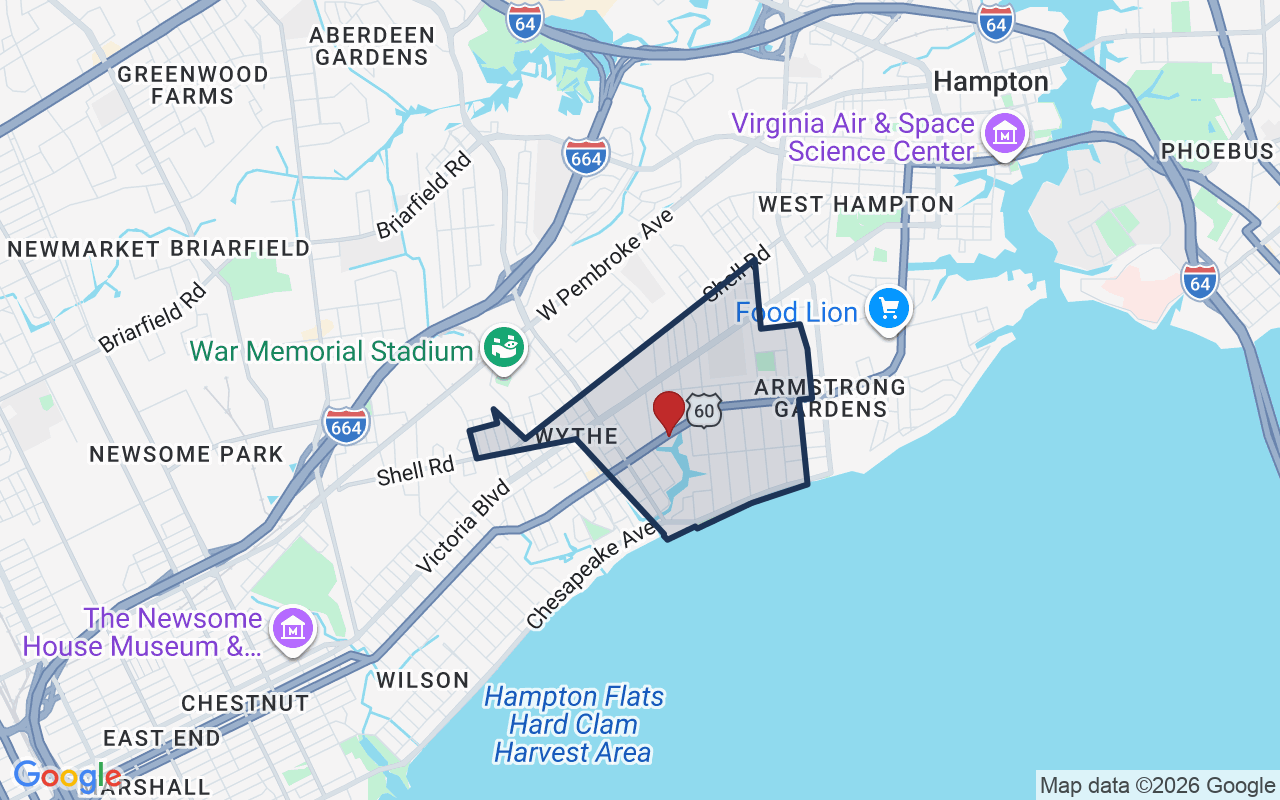
Hampton Roads is a REIN MLS subdivision in Hampton, Virginia — a waterfront neighborhood that shares its name with the wider region. It sits close to the water and has deep ties to the sea.

$257KMedian sale · 12 mo
$172Sold $/sq ft
12dDays on market
4For sale now
$68KHH income
56.2%Owner-occupied

REIN MLS closed sales, trailing 12 mo · U.S. Census ACS 2024 5-year

Explore Hampton Roads →
Map of Hampton Roads with neighborhood boundaryNeighborhood

houses for sale in Hampton →

CostPayment calculator

Estimates only. Taxes come from the public record; confirm rates with your lender. VA-eligible buyers: $0-down financing may apply.

Estimate your monthly payment

$2,596/mo

Principal & interest

$2,127

Property tax

$349

Home insurance

$120

PMI

None

HOA/Condo (paid separately)

None

Estimate only. Association (HOA/condo) fees are paid separately and are not included in the payment above. Insurance assumed at 0.35% of home value annually. Actual taxes, insurance, and rate will vary by lender, credit, and property. Contact a lender for a personalized quote.

Value & historyComparables

Price context: similar nearby homes$235,000 – $430,000The 6 most similar homes nearby (same city, within ~20% of this size, ~2.5 mi; 6 sold). Context for judging the asking price, not an appraisal or an estimate of this home's value.
3213 Shell RD · 2.2 mi · 2,214 sqft$430,000 sold 2026-06
818 Smith ST #A · 2.2 mi · 2,000 sqft$365,000 sold 2026-02
615 Westwood AVE · 2.2 mi · 1,885 sqft$339,000 sold 2026-04

Own a home nearby? See what it is worth today: What's your Hampton home worth?

Sale & Tax History

List Price

$410,000

Price / Sq Ft

$191

Annual Taxes

$4,188

Monthly Tax

$349

HOA

None

Tax Rate (effective)

1.02%

Sale Timeline (this listing)

EventDatePriceDetail
ListedNov 7, 2026$410,000—
Currently listed—$410,000—

Looking for multi-year tax assessments or prior sales? REIN MLS only ships data for the current listing. For full property history, check the city assessor record:

Hampton Real Estate Assessor

Tax data above from REIN public-records sync. Sale timeline tracked from this listing's first appearance in our feed forward; prior owner sales are not included.

Comparable Properties

Comps are selected by city, bed count, square footage and price proximity. Composite similarity score weights bed match, sqft variance, price variance, and straight-line distance.

CompareThis home next to what else is for sale nearby

HomePriceBedsBathsSqft$ / sqft
19 Wheatland Drthis home$410,000432,141$191
Loading nearby homes for sale…

Active comparables from the REIN MLS, the same homes shown under Comparable Properties. Context for judging the asking price, not an appraisal.

Questions buyers ask

Is 19 Wheatland Dr in a good school zone?
The assigned zones on the listing record are Paul Burbank Elementary (VaHome School Score 4/10), C. Alton Lindsay Middle (VaHome School Score 6.4/10), Hampton (VaHome School Score 5.7/10). School attendance zones can change — always confirm enrollment with the local school division.
Is 19 Wheatland Dr in a flood zone?
FEMA maps this parcel in Zone AE with a base flood elevation of 8 ft — a high-risk flood band where lenders typically require flood insurance. See the flood section on this page for the full details and sources, and verify with an elevation certificate.
Does 19 Wheatland Dr have an HOA?
No — there are no HOA, condo, or association dues on the listing record for this property.
When was 19 Wheatland Dr built?
It was built in 1959, per the listing record.

Answers generated from the listing record, verified school zones, FEMA data, and cached nearby-places data. Never invented.

Tom and Dariya Milan

Tom & Dariya Milan | LPT Realty

See it in person with Tom & Dariya

We're local Hampton Roads Realtors. Pick a day and time; one of us confirms by text and meets you there. Prefer to talk first? Call or text (757) 777-7577.

Free, no obligation. One of us confirms by text, usually within the hour during the day. Your inquiry goes to Tom & Dariya, never resold. We use your details to arrange this tour and to follow up with you about it.

✆